Victoria's Wimmera Mallee Silo Art Trail, about three and a half hours from Melbourne, is the most accessible of Australia's silo art routes, with flat, sealed-road access and no climbing required. March to May and September to November suit driving best. A relaxed two to three night trip covers the highlights, anchored by Brim's photorealistic mural by Guido van Helten. Western Australia's trail is more remote, requiring a flight to Perth and a week or more.
Why Silo Art Has Become a Serious Road-Trip Reason
It started as a creative response to rural decline. Towns that once thrived on rail freight and wheat marketing found themselves with monumental grain infrastructure and not much foot traffic. The solution — commissioning internationally regarded street artists to paint the silos — turned out to be one of the more inspired ideas in Australian regional tourism. People genuinely drive hundreds of kilometres for them.
For a solo traveller in his late sixties with a decent car and no particular need to rush, these trails offer something that package tours rarely do: a reason to stop in places that aren't on the usual itinerary, talk to locals at the pub, and sit with a flat white while the light changes on a painted concrete wall. The art is serious. The towns are real. The pace is entirely yours.
Each state's collection has its own character. Victoria's is the most polished and visitor-ready. WA's is the most epic in scale and remoteness. NSW is quieter and less signposted but holds its own. Queensland is still finding its feet, which, depending on your temperament, is either a drawback or an advantage.
Victoria's Wimmera Mallee Trail: The One That Started It All
The Wimmera Mallee Silo Art Trail runs roughly along the Borung Highway and surrounding roads through the grain country northwest of Melbourne. The core towns — Brim, Sheep Hills, Rupanyup, Lascelles, Rosebery, Patchewollock and Hopetoun — are each separated by between 30 and 70 kilometres of flat, arrow-straight highway. From Melbourne, Brim is around three and a half hours via the Western Ring Road and the Calder and Borung highways. Confirm current road conditions on VicRoads (vicroads.vic.gov.au) before departing, particularly after wet winters.
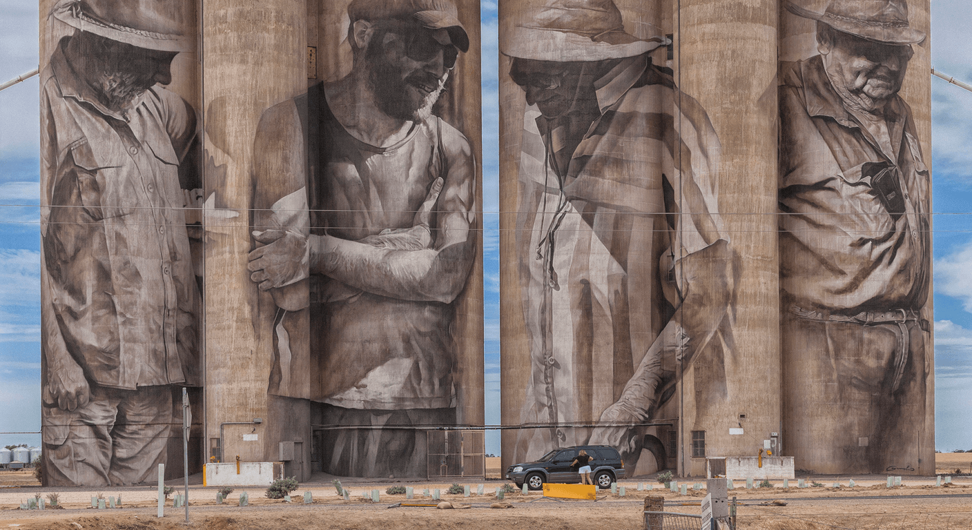
Brim's silo, painted by Guido van Helten in 2016, is widely regarded as the work that gave the trail its credibility. It depicts local grain farmers rendered in a photorealistic style that rewards time spent looking. Rupanyup has a pair of silos with portraits by Julia Ciccarone that are among the most technically accomplished in the country. Sheep Hills carries a mural by Adnate with a strong Indigenous-influenced aesthetic. None of these towns are large — Rupanyup has a population of a few hundred — but most have a pub, a bakery or a general store. Fuel up at Warracknabeal or Hopetoun before heading into the smaller stops; don't assume every town has a servo.
The trail is genuinely flat and the silos are accessible from sealed road shoulders or adjacent car parks. There are no significant gradients, no need to climb anything, and most sites have at least basic facilities nearby. Two nights away from Melbourne — one in Warracknabeal or Donald, one further along the trail — gives a relaxed pace without feeling rushed. The Wimmera Mallee Tourism website lists current town facilities and accommodation options; check it before you go.
Western Australia's Public Silo Trail: Scale and Solitude
WA's Public Silo Trail is a different proposition entirely. The trail spans a broad arc through the wheatbelt and south coast, taking in Northam, Merredin, Ravensthorpe, Esperance, Albany, Katanning and beyond — a loop that, driven in full, covers well over 2,000 kilometres. For a Victorian traveller, that means flying to Perth first, hiring a car, and committing at least a week. Flights from Melbourne to Perth run around four and a half hours; confirm current schedules and fares with your preferred airline.
Northam, roughly 100 kilometres east of Perth, is a logical first stop and a comfortable drive from the airport. The silo there, painted by Smaro Papaevangelou, is a good introduction to the scale of the WA works — these silos are often taller and more architecturally dramatic than their Victorian counterparts. Ravensthorpe, further south near the coast, requires a longer drive of roughly 500 kilometres from Perth and sits in genuinely remote country. Fuel planning is non-negotiable; carry a jerry can if you're heading off the main highways.
The WA trail suits someone comfortable with long drives and willing to spend nights in small country towns where the pub is the social hub and the Wi-Fi is unreliable. Accommodation in Ravensthorpe, Hopetoun and the smaller stops is limited — book ahead. Tourism Western Australia's official website has a downloadable trail map and current town information. The scale of the landscape around these silos is part of the experience; the art doesn't exist in isolation from the country it's painted in.
New South Wales: Grenfell, Barellan and the Quieter Collection
NSW hasn't pursued silo art with the same coordinated energy as Victoria or WA, but Grenfell and Barellan — both in the central west — have murals worth the detour. Grenfell is around 350 kilometres west of Sydney and 450 kilometres north of Melbourne via the Hume and Olympic Highways; it's a solid half-day drive from either city. The town is better known as the birthplace of Henry Lawson, but the silo mural adds a contemporary reason to stop. Barellan, roughly 100 kilometres south of Griffith, has a mural and is conveniently placed if you're driving between Melbourne and the Riverina.
These are honest country towns rather than tourist destinations, and that's part of the appeal. The silos aren't always prominently signposted, so downloading a map from the local council website or checking Google Maps before you leave is practical advice. Fuel and food are available in Grenfell itself. Accommodation is limited but functional — pub rooms and a handful of motels. Visit Grenfell's website (visitgrenfell.com.au) has current information on facilities.
NSW's collection works best as a component of a longer Riverina or central west road trip rather than a standalone journey. If you're already heading to Wagga Wagga, Griffith or Orange, building in a silo stop adds genuine interest without significantly extending the drive. The art is less famous than Victoria's but the towns feel less discovered, which some travellers will consider a virtue.
Queensland's Growing Collection: Darling Downs and Beyond
Queensland's silo art scene is centred on the Darling Downs, with works near Jondaryan, Tara and a handful of other grain towns west of Toowoomba. Toowoomba itself is around 130 kilometres west of Brisbane, making this the most accessible collection for Queensland-based travellers and a feasible overnight trip for those flying into Brisbane. From Melbourne, a flight to Brisbane followed by a hire car to Toowoomba is the practical approach — confirm current flight times and routes before booking.
The Jondaryan Woolshed precinct, already a regional attraction in its own right, sits near some of the newer silo works, which makes for a natural pairing. The Darling Downs landscape — wide, flat, grain-country — echoes the Wimmera in character. Two new silos near Jondaryan were confirmed for 2026 completion; check Queensland Country Tourism's website for current status before making the trip specifically for them.
Queensland's collection is worth including if you're already in the southeast corner of the state, but it's not yet developed enough to justify a dedicated long-haul journey from Victoria on its own. That may well change. The Darling Downs has the infrastructure — good highways, reasonable motel accommodation in Toowoomba and Dalby — to support a comfortable regional loop.
Practical Self-Drive Planning: Fuel, Toilets and Pacing
Every silo art trail passes through towns where basic services can't be assumed. The consistent advice from experienced grey nomads is to treat fuel as a priority rather than an afterthought. On the Wimmera Mallee trail, fuel is reliably available in Warracknabeal, Hopetoun and Donald; smaller towns may have a servo but hours can be limited. On the WA trail, the distances between reliable fuel stops increase significantly once you leave the main highways — Merredin to Ravensthorpe, for instance, requires planning. Download the Petrol Spy app or use the MotorMouth website (motormouth.com.au) to check current servo locations and prices before departing.
Toilets at silo sites vary considerably. Some have purpose-built facilities installed as part of the tourism development; others have nothing. Roadside rest areas on the Borung Highway and the Great Eastern Highway in WA generally have facilities, but checking the relevant state road authority's rest area map is worth doing. In Victoria, VicRoads and the Department of Transport publish rest area information; in WA, Main Roads WA (mainroads.wa.gov.au) covers the wheatbelt routes.
Pacing is the thing that makes or breaks these trips for travellers over 50. Two silos per day, with a long lunch and an afternoon rest, is a comfortable rhythm. Starting drives before 9am in summer avoids the worst heat and glare. A car with a decent cooler, a hat, sunscreen and a refillable water bottle are not optional extras. Most of the silo towns have a pub or bakery that will do a counter lunch; calling ahead to confirm hours is sensible in the smaller stops.
Which Trail Is Right for You?
For a Victorian-based traveller doing this for the first time, the Wimmera Mallee trail is the obvious starting point. It's close, well-documented, and the art is genuinely excellent. Two or three nights away from home, a reliable car and a loose itinerary is all that's required. It's the kind of trip that costs less than a week interstate and delivers more than most people expect.
WA's trail is the one to save for when you want a bigger adventure — a week or more, a flight, and the particular pleasure of driving through country that feels genuinely remote. It rewards people who are comfortable with self-sufficiency and don't need a café on every corner. NSW sits somewhere between the two: quieter, less polished, but honest and worth including in a broader regional itinerary. Queensland is one to watch rather than one to chase right now.
All four states charge nothing to view the art. The cost of the trip is fuel, accommodation and food — and your time, which at 69 and retired is the one currency you're spending wisely. These trails are, in their quiet way, some of the best reasons to drive through the Australian interior that anyone has come up with in years.
Quick planning guide
| Ideal pace | Slow-paced — around two silos a day with a long lunch and rest |
|---|---|
| Best months | March to May and September to November |
| Suggested stay | Two to three nights for Victoria's trail; a week or more for WA's |
| Mobility level | Easy — flat terrain, sealed road-shoulder access, no climbing |
| Cost level | Budget-friendly — viewing is free; costs are fuel, accommodation and meals |
| Comfort level | Basic — limited country-town facilities, book accommodation ahead |
| Best for | Retirees and self-drive travellers who enjoy unhurried regional touring |
| Main planning consideration | Fuel planning — small towns can't be assumed to have an open servo |
Key takeaways
- Victoria's Wimmera Mallee Silo Art Trail is the most developed and accessible, reachable within a three-and-a-half-hour drive from Melbourne.
- WA's Public Silo Trail covers over 2,000 kilometres and requires at least a week; fly to Perth and hire a car.
- All silo art viewing is free of charge across every state — costs are fuel, accommodation and meals.
- Fuel planning is essential on every trail; do not assume small towns have operating servos.
- March to May and September to November are the most comfortable months to drive any of these trails.
- NSW's Grenfell and Barellan silos work best as part of a broader Riverina or central west road trip rather than a standalone journey.
Recommended partners and links
Indicative prices only — always confirm with the operator before booking.
Frequently asked questions
How long does it take to drive the Wimmera Mallee Silo Art Trail in Victoria?
The core Wimmera Mallee Silo Art Trail — taking in Brim, Sheep Hills, Rupanyup, Lascelles, Rosebery, Patchewollock and Hopetoun — can be driven in two to three days from Melbourne at a comfortable pace. The towns are spread across roughly 200 kilometres of highway, with 30 to 70 kilometres between stops. Two nights' accommodation in the region is a sensible minimum; Warracknabeal and Hopetoun both have motel and pub accommodation.
Is there an entry fee to see the silo art murals in Australia?
No. All silo art murals across Victoria, Western Australia, New South Wales and Queensland are viewable free of charge from public roads or roadside areas. There are no tickets, no gates and no booking required. Your only costs are getting there — fuel, accommodation and food.
What is the best time of year to do a silo art road trip in Australia?
March to May and September to November are the most comfortable months across all states. Summer (December to February) brings extreme heat to the Wimmera, WA wheatbelt and Queensland's Darling Downs — temperatures above 40°C are possible and make long drives genuinely uncomfortable. Winter is mild and pleasant in Victoria and WA but can bring cold nights. Spring and autumn offer the best balance of mild temperatures and clear light for photography.
How do I get to the WA Public Silo Trail from Melbourne or Sydney?
The most practical approach is to fly to Perth and hire a car. Flights from Melbourne to Perth take roughly four and a half hours; from Sydney, around five hours. Confirm current schedules and fares with your preferred airline before booking. Once in Perth, Northam — the logical first stop on the trail — is around 100 kilometres east of the city on the Great Eastern Highway. The full trail covers well over 2,000 kilometres, so allow at least a week.
Are the silo art sites accessible for travellers with limited mobility?
Most silo art sites across all states are accessible from sealed road shoulders or flat car parks, with no significant gradients or climbing required. The art is large-scale and visible from a vehicle if walking is difficult. Toilet facilities vary by site — some have purpose-built amenities, others have nothing nearby. Check the relevant state tourism or road authority website for current facilities at specific stops before planning your route.