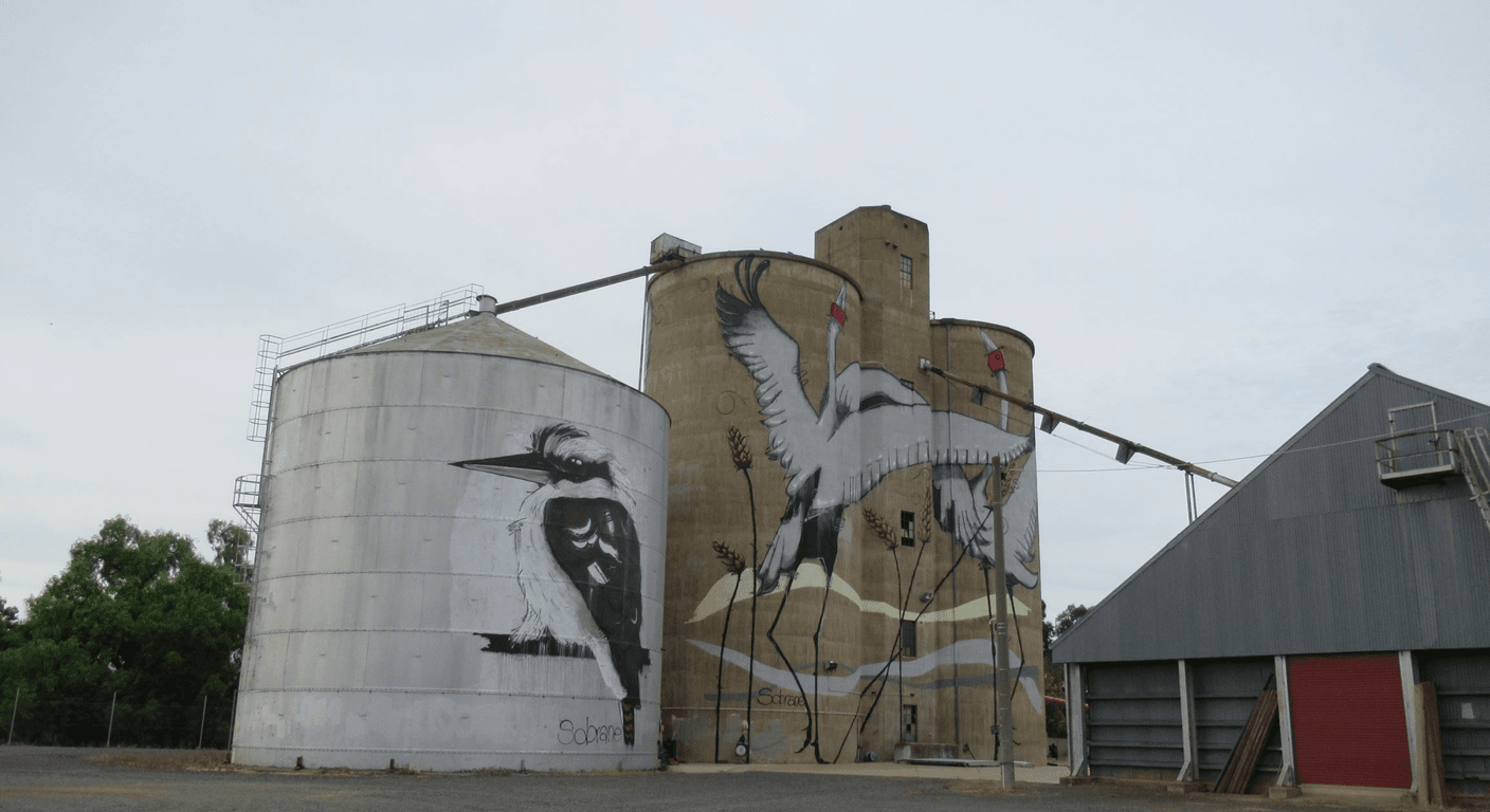
Painted grain silos and water towers across regional New South Wales, Queensland, South Australia and Western Australia have turned overlooked country towns into open-air galleries, extending well beyond Victoria's well-known Wimmera trail. These are self-drive experiences, with loops ranging from a comfortable two-day NSW crossing to five-to-seven day outback itineraries in Queensland and Western Australia. Viewing is mostly roadside and easy on mobility, though fuel, rest stops and offline maps need careful planning on the longer, more remote trails.
Why Silo Art Has Become One of Australia's Most Honest Travel Experiences
There is nothing manufactured about a painted silo. It sits where it has always sat, on the edge of a wheat town that the highway bypassed decades ago, and it earns your attention by being genuinely large and genuinely surprising. The murals — some portraits of local elders, some landscapes, some abstract — were commissioned to bring visitors through towns that needed the foot traffic, and that honesty is part of what makes them worth the drive.
For a traveller in their sixties or seventies, the silo trail offers something package tours rarely do: a reason to stop in a place that isn't performing for you. The towns are real. The pubs are real. The conversations at the servo are real. That quality of encounter is increasingly hard to find, and it is exactly what draws couples who have done the overseas trips and want something that feels more grounded.
Victoria's Wimmera trail — anchored by the silos at Brim, Sheep Hills, Lascelles, Rosebery, Patchewollock and Nullawil — is the most visited and the most documented. But it is only one thread in a much larger national picture, and the trails in New South Wales, Queensland, South Australia and Western Australia are less crowded, often just as striking, and in some cases more adventurous in their subject matter.
New South Wales: The Riverina and Central West Silos
The Riverina region of southern New South Wales has developed a loose cluster of painted silos and water towers that suit a multi-day loop from the Victorian border. The silo at Grenfell, in the Central West, carries a large portrait work and sits in a town that also celebrates Henry Lawson. Tottenham, further north, has a water tower mural that is viewable from the main road through town. Ungarie and Trundle, both small wheat towns, have had public art added to grain infrastructure as part of regional revitalisation efforts — confirm current status with the Central NSW Tourism website before you go, as some works are added quietly.
The Riverina town of Corowa, near the Murray, has water tower art that connects naturally to a loop taking in Rutherglen wineries on the Victorian side. For a traveller based in northern Victoria or the Mallee, this cross-border loop can be done in a comfortable two days with an overnight in Albury or Corowa itself. The Murray Valley Highway is well-sealed and not demanding to drive, though distances between towns with fuel can stretch to 60 or 70 kilometres — check before you leave.
Photography in New South Wales is generally unobstructed; most silos sit beside public roads or at the edge of town near the railway. Morning light works well on east-facing walls, and late afternoon light is worth waiting for on west-facing ones. Bring a printed map or download offline maps before you leave a regional centre — mobile coverage on the back roads between Tottenham and Trundle is unreliable.
Queensland: Outback Trails With Serious Distance Between Them
Queensland's silo and water tower art is spread across a much larger canvas than any other state. The Darling Downs, the Maranoa and the Channel Country all have examples, but the distances between them are not day-trip distances — they are touring distances, and they need to be respected. A traveller who underestimates the gap between, say, Roma and Longreach on the Landsborough Highway is making a planning error that becomes uncomfortable quickly.
The town of Tara, southwest of Dalby on the Leichhardt Highway, has a painted silo that is accessible and well-signposted. Miles, on the Warrego Highway west of Toowoomba, has public art including water tower work that forms part of a broader heritage trail through the town. The Maranoa region around Roma has been developing public art infrastructure, and Tourism and Events Queensland's website is the most reliable current source for what is open and accessible. For travellers based in Victoria, a Queensland silo loop is realistically a five-to-seven day trip, not a day trip — factor that into your planning.
Facilities in outback Queensland are genuine concerns. Between major towns, roadhouses can be 150 kilometres apart, and not all of them have reliable toilet facilities suitable for older travellers. The Royal Automobile Club of Queensland (RACQ) publishes a regularly updated outback travel guide that lists fuel stops, water availability, and road conditions — it is worth downloading before you leave mobile range. Travelling with a printed copy is sensible.
South Australia: Yorke Peninsula and the Mid-North
South Australia has developed some of the country's most ambitious rural public art on grain infrastructure, and the Yorke Peninsula is the most accessible concentration for a visitor driving from Adelaide or crossing from Victoria. The peninsula's towns — Minlaton, Maitland, Kadina and others — each have their own character, and several have silos or water towers with commissioned artwork. The Yorke Peninsula Council and the South Australian Tourism Commission's website both carry current information on locations and access.
The mid-north of South Australia, taking in towns like Burra, Clare and Crystal Brook, offers a more varied loop that combines silo art with heritage architecture and wine country. Burra's copper mining heritage is substantial enough to carry a day on its own, and adding a painted silo or water tower stop makes the loop feel cohesive rather than forced. From Melbourne, this is a genuine three-to-four day trip, with Adelaide as a natural base.
Accessibility on the Yorke Peninsula is generally good for travellers who are comfortable walking on gravel or grass verges — there are no formal viewing platforms at most sites, and the ground around silos is often uneven. If mobility is a consideration, the view from the car window or from a sealed road edge is usually sufficient, and most murals are designed to be seen at a distance. Confirm specific access with the relevant local council before making a site the centrepiece of your day.
Western Australia: The Wheatbelt and Great Southern Trails
Western Australia's wheatbelt is the largest continuous grain-growing region in the Southern Hemisphere, and the towns scattered through it — Merredin, Mukinbudin, Kondinin, Ravensthorpe — are exactly the kind of places that have embraced silo art as a way of keeping themselves on the map. The Western Australian Silo Art Trail, which Tourism Western Australia promotes, links a number of these towns along the Great Eastern Highway and connecting roads east of Perth.
Ravensthorpe, in the Great Southern region, has a silo mural that is among the more photographed in the state, and the town sits on the South Coast Highway between Albany and Esperance — a route that is scenic and well-maintained but long. From Ravensthorpe, Esperance is roughly 180 kilometres east, and the drive is worth doing in its own right. For a traveller flying into Perth and hiring a car, a five-to-seven day loop taking in the wheatbelt silos, Albany, and the south coast is a coherent and rewarding itinerary.
The RAC (Royal Automobile Club of WA) is the best practical resource for road conditions, fuel availability, and regional travel planning in Western Australia — their website and app are more current than general travel guides. Download offline maps before leaving Perth, as wheatbelt mobile coverage drops away sharply once you are off the Great Eastern Highway. The Tourism Western Australia website carries a dedicated silo trail page with GPS coordinates for major sites.
How to Plan a Silo Loop: Pacing, Fuel, and the Case for Printed Maps
The single most common planning mistake on silo trails is underestimating how much energy a long driving day takes. Three hours behind the wheel on an open highway is not tiring in the way a city commute is, but it accumulates, and arriving at a silo in the mid-afternoon after a 400-kilometre day is not the same experience as arriving relaxed at 10 in the morning. Aim for no more than 250 to 300 kilometres of driving on any day that includes silo stops, and build in a genuine rest stop — not just a fuel stop — at least once.
Fuel planning is non-negotiable on any trail outside Victoria's Wimmera. Before each day's drive, confirm the locations of the next three fuel stops and calculate whether your tank covers the worst-case gap. Some country servos close early on Sundays, and public holidays create unpredictable closures. Carrying a small approved fuel container as a backup is a practical precaution on any route where towns are more than 100 kilometres apart.
Printed maps deserve more credit than they get. The Hema regional map series covers most of the routes relevant to silo trails, and a current paper map does not need signal, does not need charging, and does not crash. Several visitor information centres in regional towns distribute free local maps that show silo locations not yet updated on Google Maps. Pick them up when you pass through — they are often the most accurate resource available for newer murals.
Supporting the Towns That Host the Art
The reason these murals exist is that small towns needed visitors to stop, not just slow down. The most meaningful thing a silo trail traveller can do is spend money in the town — a meal at the local pub, a coffee at the bakery, a night at the caravan park or the one motel. For a town of 400 people, a dozen visiting couples each spending $60 on lunch and fuel is a genuinely significant economic event.
Many of the towns have small visitor information bays or interpretive signage near the silos that explain the artwork and the artist. Take the time to read them. Several of the Queensland and South Australian murals feature portraits of local Aboriginal elders or depict Country in ways that carry real cultural weight — understanding the context makes the experience more than a photography exercise.
If a town has a local museum or heritage centre, an hour inside is rarely wasted. These institutions are almost always volunteer-run, often undervisited, and frequently contain the kind of specific local history — a photograph of the town in 1952, a display about the wheat industry, a record of the Italian and Greek families who settled the Mallee — that no online source has digitised. For a traveller with a Greek-Australian background and a long relationship with regional Victoria, that kind of granular local story tends to resonate in a way that a capital-city gallery does not.
Quick planning guide
| Ideal pace | Slow, self-drive touring with built-in rest stops rather than long single drives |
|---|---|
| Best months | No specific season stated in the article; pacing advice focuses on daily distance rather than time of year |
| Suggested stay | Two days for a Victoria–NSW border loop, three to four days for South Australia, five to seven days for Queensland or Western Australia |
| Mobility level | Easy — most silos are viewed from the roadside or a car, with some uneven ground near sites |
| Cost level | Budget-friendly — main outlays are fuel, meals and regional accommodation rather than paid attractions |
| Comfort level | Casual and practical; facilities between towns can be basic or spaced far apart |
| Best for | Self-drive travellers and grey nomads seeking genuine regional towns over polished tourist stops |
| Main planning consideration | Spacing of fuel and rest stops on outback legs, plus offline or printed maps where mobile coverage fails |
Key takeaways
- Silo art trails extend across New South Wales, Queensland, South Australia and Western Australia — Victoria's Wimmera trail is the starting point, not the whole picture.
- Distances between silos in Queensland and Western Australia are touring distances, not day-trip distances — plan itineraries of five to seven days for those states.
- Fuel stops can be 100 to 150 kilometres apart on outback routes; confirm locations before each driving day and never leave a town on less than a half tank.
- Printed Hema maps and locally distributed visitor maps remain more reliable than mobile navigation in areas with poor coverage.
- Morning light suits east-facing murals and late afternoon suits west-facing ones — time your arrival accordingly for photography.
- Spending money in the towns that host the art — on meals, accommodation, and fuel — is the most direct way to support the communities that commissioned the murals.
Recommended partners and links
Indicative prices only — always confirm with the operator before booking.
Frequently asked questions
Which Australian state has the best silo art trail for older travellers who want manageable distances?
Victoria's Wimmera Silo Art Trail is the most accessible for older travellers, with the six main silos spread across roughly 200 kilometres of well-maintained highway between Horsham and Sea Lake. For travellers wanting to go beyond Victoria, the Yorke Peninsula in South Australia offers a compact loop that can be done comfortably in two to three days from Adelaide, with reasonable road conditions and facilities in most towns.
Can you see silo art without leaving the car or walking on rough ground?
Most silo murals are designed to be seen at a distance from a public road, and a clear view from a sealed road edge or a car window is possible at the majority of sites. Ground conditions around silos are often gravel or dry grass and are uneven, so travellers with mobility considerations should not assume a flat, paved viewing area exists. Confirm specific access conditions with the local visitor information centre before making a site the main focus of your day.
What is the best way to find up-to-date silo art locations across Australia?
The most reliable sources are the state tourism authority websites — visitnsw.com, queensland.com, southaustralia.com, and the Western Australian silo trail page on westernaustralia.com. The official siloarttrail.com site covers Victoria in detail and is a useful planning benchmark. Local visitor information centres in regional towns often hold printed maps showing newer murals not yet listed online, and these are worth picking up when you pass through.
How do you handle mobile coverage gaps on silo art routes?
Download offline maps to your phone before leaving a regional centre — Google Maps and Maps.me both support offline areas. Carry a current Hema paper map for the region you are travelling through, as these remain accurate when there is no signal. Several visitor information bays near silos have printed local maps available at no cost. Advise someone of your planned route and expected overnight stop each morning if you are travelling in areas with limited coverage.
Are there guided tours of silo art trails, or is it always self-drive?
Silo art trails are predominantly self-drive experiences, and that is a significant part of their appeal — the open road and the sense of discovery are built into the format. Some regional tour operators in South Australia and Western Australia offer small-group day tours to silo sites as part of broader agricultural or heritage itineraries; check with the relevant state tourism authority for current operators. For most travellers, hiring a reliable car and planning your own route gives far more flexibility than a structured tour.